Skip to content
 Torres del Paine Weather
Custom Windguru forecasts to help give you the best weather insights for the W Trek, O Circuit, and day hikes in Torres del Piane. The weather in Torres del Paine is Intense and you should check it as often as possible. This is a great resource for you to be able to understand the grand scheme of whats going on.
- 20+ Trail Segments
- 14 Day Hikes
- Weather Insights
West to East • 9 Stations
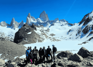
The W Trek
From Paine Grande to Base Torres — the iconic route covering glaciers, valleys, and the famous towers. Each station includes critical weather information to help you plan your journey.
Share with your partners
1
Paine Grande weather
Easy
- Short walks around the area
- 1–2 hours
- Starting the W, ferry arrival, wind baseline
Weather Notes
One of the windiest open plains; wind speed here determines the tone of the day.
View Windguru Forecast
2
Grey lookout weather
Moderate
- 11 km from Paine Grande
- 3–4 hours
- Getting to Mirador Grey + Refugio Grey
Weather Notes
This is the notorious wind accelerator zone. Gusts often exceed forecast by 2× due to funnelling.
View Windguru Forecast
Refugio Grey weather
Moderate
- +4 km beyond Mirador Grey
- 1–1.5 hours
- Glacier visibility, morning light
Weather Notes
Cloud base is key for glacier views; early morning is usually best.
View Windguru Forecast
Valle Francés weather
Moderate
- 7.5 km from Paine Grande
- 2.5–3 hours
- Deciding if the valley is safe to climb
Weather Notes
Cloud ceiling determines visibility; rain & avalanche noise are common.
View Windguru Forecast
Mirador Británico weather
Hard
- 2 km from Italiano
- 1–1.5 hours
- Francés Glacier avalanches & wall views
Weather Notes
Needs stable skies. If cloud base is low, visibility is almost zero.
View Windguru Forecast
Campamento Italiano
Hard
- 5 km round trip from Francés
- 2–3 hours
- The best amphitheater view in the park
Weather Notes
Only worth attempting if cloud base is high and wind moderate.
View Windguru Forecast
Cuernos Sector weather
Moderate
- 5.5 km from Italiano
- 2 hours
- Transition between valleys
Weather Notes
One of the windiest open plains; wind speed here determines the tone
View Windguru Forecast
Chileno campsite
Moderate
- 13 km from Cuernos
- 4–5 hours
- Planning Torres Base ascent
Weather Notes
Wind, rain, cloud base — all affect next day's sunrise mission.
View Windguru Forecast
Mirador Base Las Torres
Easy
- 4 km steep ascent
- 2 hours
- Viewing Las Torres
Weather Notes
Cloud base here is everything. If cloud base 50 km/h → dangerous near the moraine.
Wg forecast
Full Loop • 6 Additional Stations
The O Circuit weather forecast
The complete circuit includes all W Trek stations plus the remote northern sections. Features the legendary John Gardner Pass — the most challenging and weather-dependent segment in the park.
Share with your partners
Laguna Amarga / Torres Hotel Area
Easy
- Entrance area
- N/A
- Establishing the baseline weather before starting
Weather Notes
Good cloud-base indicator for upcoming Torres days.
View Windguru Forecast
Serón Sector
Moderate
- 13 km from Torres Hotel
- 4–5 hours
- Day 1 of O Circuit
Weather Notes
Extremely windy pampas. Crosswinds can be hazardous.
View Windguru Forecast
Dickson Sector
Moderate
- 18 km from Serón
- 6–7 hours
- Stunning lake & glacier views
Weather Notes
Northern storms arrive fast. Weather system differs from central park.
View Windguru Forecast
Los Perros campsite
Moderate
- 12 km from Dickson
- 5–6 hours
- Glacier Los Perros access
Weather Notes
High rainfall. Mud. Low visibility. A completely different ecosystem.
View Windguru Forecast
John Gardner Pass (Highest Point)
Very Hard
- 22 km to Grey
- 8–10 hours
- Crossing the spine of the O Circuit
Weather Notes
The most important weather zone in all TDP. Wind determines if the pass is open. Cloud base determines visibility. Gusts can be violent.
View Windguru Forecast
Paso Ranger Station & Campsite
Hard
- After the pass
- 1 hour
- Planning descent safely
Weather Notes
Still very exposed; fog risk. d
View Windguru Forecast
Shorter Adventures
Day Hikes in Torres del Paine
Top day hikes in Torres del Paine that are not part of the W Trek or O Circuit. Perfect for visitors with limited time or looking for less strenuous adventures.
Share with your partners
Laguna Azul
Moderate
- 1.5–3 hours
- One of the best distant views of the Torres; quiet and far fewer people
Weather Notes
Great on windy days since it's more sheltered.
View Windguru Forecast
Mirador Condor (Lago Pehoé)
Moderate
- 1–1.5 hours
- Panoramic views of Pehoé, Paine Grande, Los Cuernos
Weather Notes
Strong winds possible; one of the most photogenic viewpoints in the park.
View Windguru Forecast
Salto Grande Waterfall Walk
Easy
- 20–40 minutes
- Powerful waterfall + wind blasts
Weather Notes
Often used as a 'bad weather activity.'
View Windguru Forecast
Mirador Cuernos (from Salto Grande)
Easy
- 1–1.5 hours
- Close-up view of the Cuernos and waterfall
Weather Notes
Extremely popular and crowded; great for people with limited time.
View Windguru Forecast
Mirador Nordenskjöld
Easy
- 1–2 hours
- Great lake views beneath the Cuernos
Weather Notes
Many photographers stop here.
View Windguru Forecast
Sarmiento Lake Lookout Trail
Easy
- 1–2 hours
- Bleached-white calcium formations, puma territory
Weather Notes
Excellent sunrise spot.
View Windguru Forecast
Laguna Amarga Lookouts
Easy
- 20–30 minutes
- Wide views of the Torres from afar
Weather Notes
Good for watching sunrise colors.
View Windguru Forecast
Pingo Valley Trail
Moderate
- 3–6 hours
- Forested valley, wildlife, fewer people
Weather Notes
A more secluded hike, great on windy days.
View Windguru Forecast
Lago Grey (short walk to the beach)
Easy
- 30 minutes
- Icebergs + Glacier Grey views
Weather Notes
Can be extremely windy; popular with day visitors.
View Windguru Forecast
Mirador Ferrier
Hard
- 3–4 hours
- One of the best elevated viewpoints in the park
Weather Notes
Very steep but rewarding; wind can be extreme.
View Windguru Forecast
Lago Toro Viewpoint
Moderate
- 1–2 hours
- Massive view over Toro Lake toward Paine Massif
Weather Notes
Great alternative to Mirador Condor.
View Windguru Forecast
Laguna Verde Loop
Moderate
- 2–3 hours
- Birdwatching, quiet forest, great Torres silhouette views
Weather Notes
A local favorite — almost no crowds.
View Windguru Forecast
Peninsula de Serrano Nature Trails
Easy
- 1–2 hours
- Very calm southern views of the park
Weather Notes
Good for families and windy days.
View Windguru Forecast
Porteño Lake Shoreline Trail
Easy
- 1–2 hours
- Guanacos, open landscapes
Weather Notes
Often overlooked but beautiful.
View Windguru Forecast
How to Read Patagonia Weather the Right Way
Step 1: Check wind gusts (safety first). Look at the row labeled Wind gusts (km/h). This shows the strongest bursts of wind and is the most important safety factor. Use this scale: 0–25 km/h is excellent and very safe. 25–40 km/h is good and normal for Patagonia. 40–60 km/h is moderate and requires caution, especially on exposed sections. 60–80 km/h is dangerous and summits should be avoided. 80+ km/h is severe and unsafe for hiking. For hikes like Laguna de los Tres, gusts above 60 km/h can make the final ascent difficult or unsafe.
Step 2: Check low cloud cover (main visibility factor). Look at Low cloud cover (%). This is the most important factor for mountain visibility. 0–20% means clear views. 20–40% means good visibility. 40–70% means partial visibility. 70–100% means the mountains are likely blocked. Low clouds sit directly on the mountains and can completely hide peaks like Fitz Roy even if other conditions look clear.
Step 3: Check mid cloud cover (secondary visibility factor). Look at Mid cloud cover (%). These clouds can also block mountain views. 0–20% means clear conditions. 20–40% means good visibility. 40–70% means partial visibility. 70–100% means poor visibility. The best hiking conditions occur when both low and mid cloud percentages are low at the same time.
Step 4: Scan hour-by-hour to find the best window. Windguru provides hourly forecasts, which helps identify the best time to hike. Look for hours when wind gusts decrease and cloud percentages drop. Conditions often improve later in the morning or early afternoon. Even a few hours of lower wind and cloud cover can provide a good hiking window.
Step 5: Check precipitation last. Look at Precip. (mm/1h) to see rain or snow. 0 mm means dry. 0.1–0.5 mm means very light precipitation. 0.5–2 mm means light rain. 2+ mm means moderate to heavy rain. Light rain is usually manageable, but strong wind combined with rain creates much worse conditions.
Guided Day Activities
Glacier Grey Navigation
Via Lago Grey boat — great for non-hikers wanting glacier views up close.
Horseback Riding
Extremely popular alternative to hiking — to Laguna Azul or Serrano sector.
Torres del Paine weather, frequently asked questions (FAQ)
Is it still worth hiking Base Torres if the forecast is cloudy?
Yes, as long as there is not strong winds along with it I recommend you take advantage of all the time you have here. I have seen incredible photos of days that are cloudy.
What is the best website or app to check the weather in Torres del Paine?
Windguru, Meteo blue and Windy are the three most trusted weather sites, most mountain guides use Windguru.
Should we still do the Base Torres hike if it’s really windy or raining, or is that too dangerous?
Wind speeds above 35 mph (56 km/h) can make walking unstable and may push you off balance, especially with a backpack. High winds are common in Torres del Paine and can significantly increase the difficulty and risk of the hike. Always check the latest weather forecast before starting and wait for safer conditions if strong winds are expected.
What will the weather be like in Torres del Paine during my trip?
Weather is highly changeable year-round, so you should expect a mix of sun, cloud, rain, and strong wind even in summer. Check forecasts a few days before you arrive, but always plan for worse conditions than predicted.
Is it safe to camp in Torres del Paine with cold, snow, or strong wind in the forecast?
It can be safe if you have proper gear (four-season or very sturdy tent, warm sleeping bag, good anchors) and experience camping in rough weather. If you’re unsure about your gear or skills, consider refugios or adjusting your itinerary on the worst days.
What are the best alternative plans if the weather looks bad for several days in Torres del Paine?
On rough days, many people switch to shorter, lower-elevation walks, viewpoints near refugios, or sheltered excursions from Puerto Natales. You can also shift your “big” hikes to the most stable day and keep the rest flexible for museums, viewpoints, and road-based sightseeing.
How should I prepare for sudden storms, snow, or severe wind in Torres del Paine?
Dress in layers, carry a waterproof shell and pack cover, and always have hat, gloves, and extra warmth in your daypack. Build flexibility into your itinerary so you can shorten or skip sections if conditions deteriorate.