Skip to content
 Laguna de los Tres
Laguna de los Tres is a famous day hike in El Chalten, Argentina. It’s a 22.5 km roundtrip hike that has a quite difficult steep section at the end. The overall elevation gain is 900-1050 meters. It usually takes 7-9 hours to finish and it is the hardest day hike in El Chalten.
★★★★★ 5.0 on Google 130+ verified traveler reviews
We Helped 3000+ travelers in 2025 with free weather reports


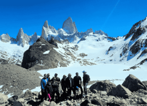
Laguna de Los Tres hike
Laguna de los Tres is the most popular hike in El Chaltén, following a demanding 22.5 km route to the closest major viewpoint beneath Mount Fitz Roy. Although no official trail-specific count is published, an estimated 100,000–150,000 people attempt the hike each year.

Distance: 22.5 Km ( 13.5 miles ) | Elevation gain: 900-1050 Meters (2.950- 3.450 feet) | Duration: 7-9 hrs | Difficulty: Hard
Start of the Laguna de los Tres hike
The Laguna de los Tres hike starts directly in El Chaltén, so you can walk from your accommodation to the trailhead without needing transfers. Unless you would like to start from Rio Electrico which is a 25 minute taxi ride. If you would like a taxi I can help arrange this. The path begins at the northern end of town, where Avenida San Martín meets the start of the Fitz Roy / Laguna de los Tres trail.
First climb and early viewpoints
The hike begins with a steady uphill climb of about 1 km, where you gain elevation quickly right from the start. Near the top of this first section you reach Mirador del Río de las Vueltas, offering your first open views back over the valley and the winding river below; after this, the next 2 km become gradually easier on the legs.
Laguna Capri junction
From the first viewpoint, the trail continues through an old lenga forest with gentle ups and downs as you keep gaining a bit of elevation. At around 3.5 km you reach a signed junction where you can choose a short detour to Laguna Capri or continue straight toward the Fitz Roy viewpoint.
Laguna Capri – Campamento Poincenot
Continuing from either Laguna Capri or Mirador Fitz Roy, the trail runs through the valley for roughly 5 km of mostly flat and rolling terrain. This section gives you wide views of the Fitz Roy massif, including Cerro Fitz Roy and the surrounding spires, before you arrive near the 8 km mark at Campamento Poincenot, a popular forest campsite beside the Río Blanco where many hikers stop for a rest or lunch.
Final steep section to Laguna de los Tres
After crossing the river close to Campamento Poincenot, the final section of the hike begins. Here the path climbs steeply for about 1 km up rocky switchbacks, gaining roughly 400 meters of elevation; this is the hardest part of the day and usually feels slow, especially in strong wind. This final kilometer usually takes 1-1:30 hrs.
Laguna de los Tres viewpoint
Finally you arrive to Laguna de los Tres at the viewpoint you are only 2 miles as a crow flies from Mount Fitz Roy. Many hikers take a long break or have lunch here, and when the wind is too strong it often feels better to eat a bit lower down in the shelter of the lenga forest near Campamento Poincenot.
Mirador Laguna Sucia
From the main viewpoint, there is an optional 20-minute extension along the moraine ridge to Mirador Laguna Sucia. This short side trip lets you look down onto a hidden darker lake below and across toward the Piedras Blancas glacier, adding another dramatic angle to the scenery before you start heading back.
Return to El Chaltén
After visiting Laguna de los Tres, you follow the same trail back to El Chaltén, with the return being mostly downhill. On the way back there is another chance to enjoy the valley, forests, and mountain views from a new angle, and you can still choose to detour to Laguna Capri if you skipped it earlier or if the afternoon light looks good for photos.
Route Options for Laguna de los Tres
Laguna de los Tres can be reached from two different trailheads. You can begin directly in El Chaltén and return along the same trail, or take a transfer to Río Eléctrico and complete a point-to-point hike ending in town. Both routes meet near Campamento Poincenot before the final climb to Laguna de los Tres.
Starting from Río Eléctrico
Morning transfer from El Chaltén to the Río Eléctrico trailhead
Follows the Río Blanco valley through native forest
Passes the viewpoint for Glacier Piedras Blancas
Reaches Campamento Poincenot before the final climb
Avoids repeating the same trail in both directions
Returns through the Fitz Roy valley after Laguna de los Tres
Passes Mirador Fitz Roy and Laguna Capri
Finishes directly in El Chaltén
Point-to-point route with a different distance and elevation profile
Hiking tips for Laguna de los Tres

Learn Windguru
Learning how to read Windguru forecasts will allow you to optimize your time here in El Chaltén. I give free Consultations on how to read and also provide daily weather reports that can help you chose the best date to hike Laguna de los Tres.

Start early to avoid crowds
Starting early not only allows you to capture the Alpenglow on the mountains but if conditions are good. You can expect 1000+ people heading towards the same place. Starting at 5:00 am or earlier allows you to beat the crowd up and if you are heading down before 11:00 you will avoid the giant crowds coming up to Laguna de los Tres.

Trekking poles
I always bring trekking poles. They help so much if my knees start hurting me coming back down from Laguna de los Tres. They can help you set a nice pace and also help you from tripping. Highly recommend. If you would like to rent trekking poles or any other gear I provide this service also.
Frequently Asked Questions About Hiking Laguna de los Tres.
Is hiking Laguna de los tres safe?
Yes, hiking Laguna de los tres is relatively safe. But like all hikes in El Chaltén it has its dangers. Wind and weather complicate the hike also the different seasons create variables. I would like to say the trail is well marked, but if you are found in bad weather it can be easy to take a wrong turn and you will find yourself taking the long way home. Use an app like Gaia GPS to help you stay on trail.
Do I need trekking poles for the hike?
Yes, many hikers I’ve talked with have said they thought they didn’t need them, but the rocky steep section going up and down made them very grateful they had them.
How long is laguna de los tres hike?
The Laguna de los Tres hike is 22.5 kms (14 miles) its usually completed in 8-10 hours.
Is there snow/ice on the Laguna de los tres hike?
Yes, anytime of the year Ice and snow can be present on the final steep section of Laguna de los tres.
Is the alternative route via Laguna Torre worth it?
If you are more experienced and want to squeeze in one big long day I would recommend this. The best way to do this would be to start the laguna de los tres hike from the classic start point, then on your way back this way.
Can I book for tomorrow?
Yes, next-day bookings are often possible, depending on guide availability, transportation, and weather conditions. Contact us as early as possible with your group size, preferred route, and accommodation details so we can confirm availability.
How bad is the final ascent?
The final climb to Laguna de los Tres is widely considered the hardest section of the hike. It gains approximately 400 metres of elevation over just 1 km, following steep, rocky switchbacks to the top.
Most hikers take between one and two hours to complete this section,
Is there an entrance fee for hiking Laguna de los Tres?
Yes. Since October 2024, Los Glaciares National Park charges an entrance fee for Laguna de los Tres. A single-day pass is 50,000 ARS as of June 1st 2026. Visitors can also buy 3-day or 7-day passes that reduce the daily cost.
Entrance fee link
I Will Capture Your Adventure in El Chaltén?
Every moment in Patagonia is a masterpiece waiting to be captured. With our professional photography services, you can relive this magical place in the world, and your incredible journey for years to come. Let us turn your adventure into a story you’ll cherish forever.