 Skip to content
El Chaltén, Argentina
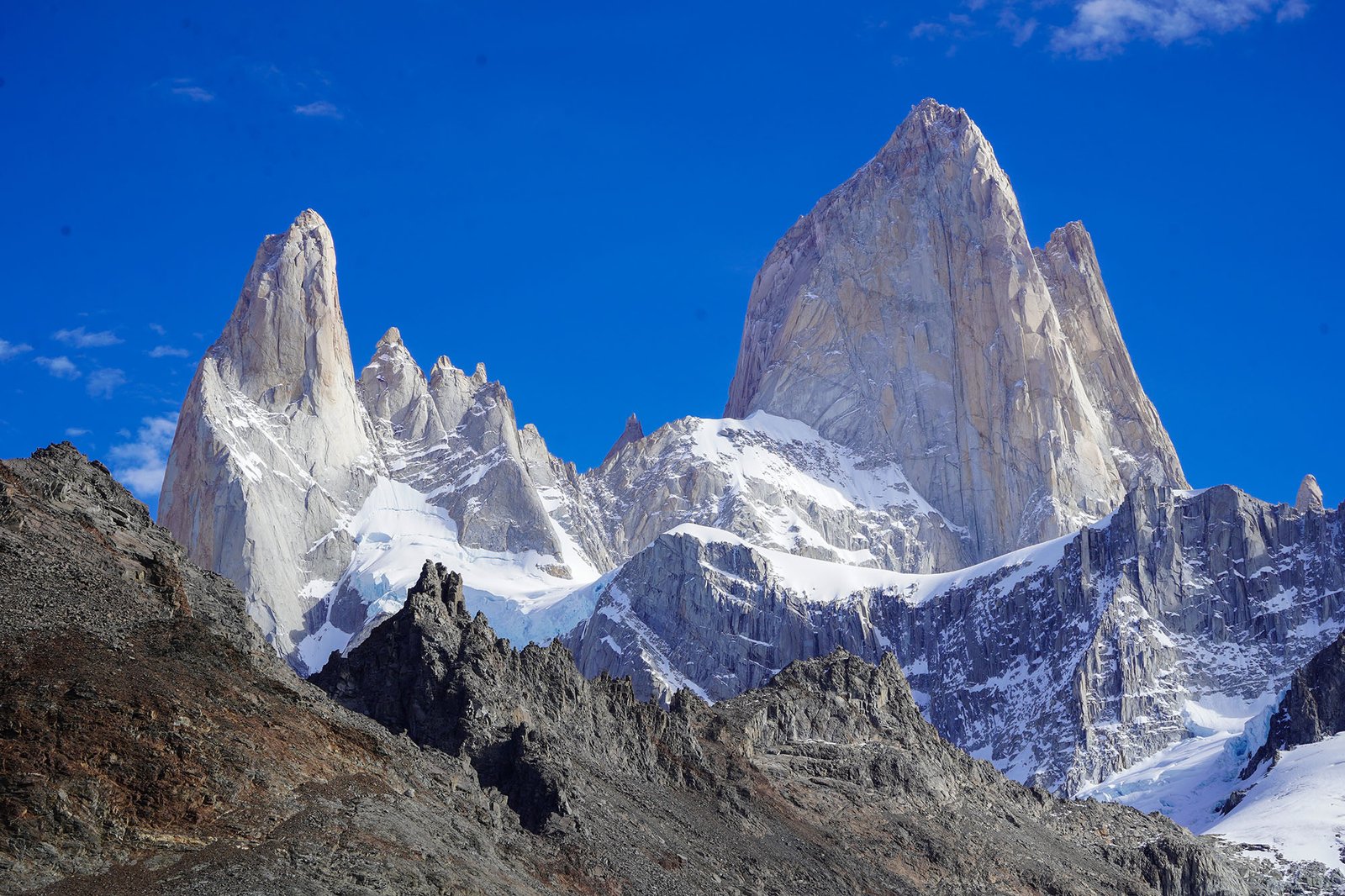
El Chaltén is Argentina’s National Trekking Capital, a small mountain town in Los Glaciares National Park with direct access to trails beneath Mount Fitz Roy and Cerro Torre.
Founded: October 12, 1985
Location: Santa Cruz Province, Argentina
Region: Southern Patagonia
Known for: Mount Fitz Roy, Cerro Torre, Trekking.
Recommended stay: 5–7 full days
Popular Hikes: Laguna de los Tres, Laguna Torre, Loma del Pliegue
Latitude and Longitude: 49°19′53″ S, 72°53′10″ W
Recommended stay: 5–7 full days
Founded: October 12, 1985
Year round population: 3000
Known for: Fitz Roy, Cerro Torre, Huemul Circuit
Recommended stay: 5–7 full days
How many days should I stay in El Chaltén?
I highly recommend spending at least five full days in El Chaltén, excluding your arrival and departure days. Three full days is the bare minimum if you want a reasonable chance to hike Laguna de los Tres, visit Laguna Torre, and complete some of the shorter hikes, but it leaves very little flexibility for poor weather.
Based on close monitoring of El Chaltén’s weather and trail conditions, a five-day stay gives visitors a much better chance of finding at least one favorable weather window for a major hike. Staying for five to seven days also allows you to schedule the most important hikes on the clearest days while keeping one day available for recovery or as a weather buffer.
I have helped thousands of visitors find the best weather windows for clear views of Fitz Roy, whether they were staying for one day or an entire month. From the day you arrive until the day you leave, I send daily weather reports to help you decide when to hike.
El Chaltén trip-length comparison chart
| Full days in El Chalten | What you can realistically do | Main limitation | Good visibility window odds |
|---|---|---|---|
| 1–2 days | Complete one major hike or several shorter walks | Almost no flexibility around poor weather | 10–25% |
| 3 days | Complete two major hikes and one shorter outing | Your plans remain highly dependent on the forecast | 25–35% |
| 5 days | Complete the major hikes with time for recovery and one buffer day | Clear conditions are still not guaranteed | 45–65% |
| 7 days | Add more hikes, photography days, and greater weather flexibility | Higher accommodation and travel costs | 65–80% |
| 8–10 days | Complete multi-day treks and explore beyond the main day hikes | More time than most casual visitors need | 75–95% |
The visibility percentages are practical estimates based on my local weather observation, not guaranteed statistics. Conditions around Mount Fitz Roy and Cerro Torre can change quickly, for the good or the worse.
How to get to El Chalten?
El Chaltén does not have an airport. You will need to fly in or take a long 24+ hour bus ride. Most visitors first fly to EL CALAFATE INTERNATIONAL AIRPORT CTE. ARMANDO TOLA. Which has connections from either the Ministro Pistarini International Airport (What youll fly into) or the domestic Airport Jorge Newbery which is a 30min-2hr transfer depending on traffic (often times the cheaper route).
From El Calafate Airport, you can reach El Chaltén by:
Bus: The simplest and most affordable option. Some services leave directly from the airport, while others depart from the El Calafate bus terminal.
Private transfer: A convenient option for families, groups or travelers arriving outside the regular bus schedule.
Rental car: A good choice if you also plan to visit El Calafate, Perito Moreno Glacier or other destinations in southern Patagonia.
The drive from the airport to El Chaltén normally takes around 2½ to 3 hours. The road is paved, and the final part of the journey follows the shores of Lago Viedma before reaching the mountains surrounding El Chaltén.
Bus schedules and flight connections change throughout the year, so it is best to reserve transportation in advance, particularly during the main hiking season.
What is there to do in El Chalten?
Visitors can go rafting, horseback riding, or fishing, join photography tours or asado experiences, visit local cafés and restaurants, go bouldering outdoors, or use the local climbing gym when the weather is particularly bad. The climbing gym also has a small bar, making it a great place to meet locals and stay dry.
What is there to do in El Chalten if its raining?
If the weather is really not good for hiking I would suggest checking out the local climbing gym or everyones favorite cafe lounge PAISA high mountain cafe.
El Chaltén
Discover Argentina’s trekking capital, nestled in Patagonia’s stunning Los Glaciares National Park.
Where is El Chalten located?
- Southern Patagonia
Latitude -49.3315° S (or 49° 19′ 53” S) and Longitude -72.8863° W (or 72° 53′ 10” W)
- About 215 km (134 mi) north of El Calafate (the nearest airport town)
- Accessible via Route 23 off the iconic Ruta 40
Size of El Chalten
- Population: 3000+
- Area: The developed town covers roughly 50 hectares (0.5 km²)
- Elevation: About 420 meters (1,312 feet) above sea level
Primary features of El Chalten
- Cerro Fitzroy and Cerro Torre
- Los Glaciares National Park
- Trekking in the national park
- Laguna de los Tres (to Fitz Roy base)
- Laguna Torre (viewpoint for Cerro Torre)
- World class climbing
El Chaltén hikes
El Chalten hikes are world class, that are right at your door step in El Chaltén. Theirs truly nowhere in the world like it. Here are the three best day hikes in this order; Laguna de los Tres, Laguna Torre, and Loma del Pliegue Tumbado.
Distance: 22-24Km ( 13-15 miles )
Elevation: 1178 meters ( 3865 feet )
Duration: 8-10 hrs
Difficulty: Hard
The closest and most iconic view of Mount Fitz Roy. Crampons are needed for the next 4-5 months.

Distance: 18 Km ( 11 miles )
Elevation: 1178 meters ( 3865 feet )
Duration: 5-7 hrs
Difficulty: Medium
See Patagonia’s most dramatic granite spire and glacier.

Distance: 20 km (12.5 miles) round trip
Elevation: 1178 meters ( 3865 feet )
Duration: 8-10 hrs
Difficulty: Hard
Loma del Pliegue Tumbado is a panoramic ridge hike with one of the best wide-angle views of Fitz Roy, Cerro Torre, Laguna Torre, and the Southern Patagonian Ice Field.

Frequently Asked Questions About El Chaltén
What is the weather like in El Chalten?
El Chaltén’s weather is wild and changes fast although typically, the weather on the 3 day forecast is quite accurate with Windguru and Meteoblue. Sitting at the foot of the Mount Fitz Roy, cold Antarctic air meets Pacific moisture here in a way that produces conditions unlike almost anywhere else on earth.
Average yearly high: ~13°C
Average yearly low: ~3°C
What to do in El Chalten argentina?
Visitors can go rafting, horseback riding, or fishing, join photography tours or asado experiences, visit local cafés and restaurants, go bouldering outdoors, or use the local climbing gym when the weather is particularly bad. The climbing gym also has a small bar, making it a great place to meet locals and stay dry.
Should I hire a guide in El Chalten?
Hiring a guide in El Chaltén is highly recommended when theirs bad weather, shoulder season, lack expierence or want a masterclass explanation of the park. A local guide improves safety and ensures you make the most of your experience. Guides also provide insight into Patagonia’s weather, wildlife, and terrain, making your hike safer and more enjoyable.
What to wear hiking in Patagonia?
Base layer: Merino wool, not cotton. Mid layer- Fleece (preferred over down while hiking, breathes better when you sweat). A down/synthetic puffer is 100% needed for camp, also for when you or the group needs a longer break.
Where is El Chalten?
El Chaltén is a small mountain village in Santa Cruz Province, Argentina, often called the “National Capital of Trekking.” It is located in southern Patagonia, near Los Glaciares National Park, at the base of Mount Fitz Roy and Cerro Torre, approximately 220 kilometers north of El Calafate. The town was officially founded on October 12, 1985.
How many days in El Chaltén?
Five days is the minimum amount of time you should stay in El Chaltén if you want to complete your dream itinerary. Patagonia’s weather can quickly disrupt your plans, but most storms do not last an entire week. Staying for at least five days gives you a much better chance of finding clear weather windows for hiking. For most visitors, five to nine days is ideal.
How do you get to El Chaltén?
Most travelers reach El Chaltén by flying into El Calafate. From there, the journey takes about three hours by bus, shuttle, or private transfer, traveling north along Ruta 40 and Ruta 23.
Some travelers also fly into Santiago International Airport (SCL), take a domestic connecting flight to Punta Arenas, and then continue overland into Argentina. The drive from Punta Arenas to El Chaltén usually takes around seven to eight hours.
Ask a Question about El Chalten
We aim to respond to all inquiries within 24 hours. Your adventure planning is our priority!
Ranch for Sale outside of El Chalten
Patagonia’s premier ranch for sale: 64,000 acres, 12 km of Lake Viedma frontage, views of Fitz Roy & Cerro Torre—ideal for retreat, cattle, or eco-tourism.
Location
80 km Proximity to El Chaltén, 150 km from El Calafate (closest airport) Lake Viedma, and Key roads.
Primary features
Lakefront, Mountains, Access roads,
Ideal for
Ranching, Tourism, Conservation, Private estate, etc.